UC Berkeley, Monday, November 9, 2026
When the Waters Rise
Free, open to everyone, and it takes under a minute.
Three leading Filipino scholars, one conversation: why does the Philippines keep flooding, who pays for it, and what can people here in the Bay Area do? Dr. Lisandro Claudio, a prize-winning Berkeley scholar of Philippine political thought and economic policy; Dr. Mahar Lagmay, the scientist behind the country's national flood hazard mapsMaps of where water would go, and how deep, if a given rain fell. Project NOAH's maps show this for rains so heavy they come about once every 5, 25 or 100 years.; and Dr. Diana Martinez, a Berkeley architectural historian of how the United States built its rule in the islands in concrete, each bring a different answer. Then stay for the reception, a space for our community to share stories, connect and learn from each other.
Co-hosted with 
Monday, November 9, 2026
UC Berkeley. Free and open to everyone. All times Pacific.
-
11 AM to 12 PM
Guest lecture by Dr. Lagmay
In Development Engineering 203, a graduate class, in B100 Blum Hall.
20 guest spots
On top of the class -
4 to 5 PM
The panel Main event
Dr. Claudio, Dr. Lagmay and Dr. Martinez in conversation, in Banatao AuditoriumNamed for Diosdado “Dado” Banatao, a Filipino-American engineer and Silicon Valley entrepreneur who also founded the Philippine Development Foundation (PhilDev)., Sutardja Dai Hall. Livestreamed: watch live. Directions · See the room
Doors open at 3:45 PM. Check in at the front desk outside Banatao Auditorium.
149 seats
Plus the livestream -
From 5 PM
Reception and community
Share stories, meet the speakers and each other, and visit tables from campus Filipino organizations, over light refreshments in B100 Blum Hall and its lobby, next door. More
For panel guests
The same 149
Can't make it to Berkeley? Stanford is hosting a talk by Dr. Lagmay on Tuesday, November 10. Details to come.
Banatao Auditorium holds 149. In-person seats go in the order people RSVP; after that there is a waitlist, and everyone can watch online.
The morning guest lecture has 20 guest spots on top of the class. It is now full, and its waitlist is closed.
Everyone is welcome, whether your family is from PampangaA province just north of Manila, in the low plains of Central Luzon where rivers flood almost every rainy season. or you have never been to the Philippines. The RSVP takes under a minute.
Who's coming
Loading the map…
The map as a list
Each figure is one person who added themselves (anonymously, separate from the RSVP), placed in their Bay Area county and, if they chose one, the Philippine province they are connected to. No names, and no towns. The blue is where a 100-year floodA flood so big it has a 1 in 100 chance of happening in any given year. It is not "once a century": it can come two years running, and warmer seas are making heavy rain more likely. would reach. The map updates about once a minute.
The speakers
Science, history and the built world: each brings a different answer to why the water keeps rising, and what we owe each other when it does. Why we put these three on one stage.
-
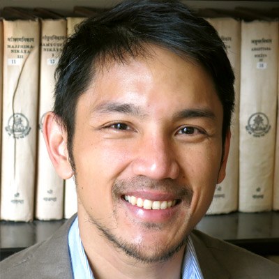
Dr. Lisandro Claudio
Associate Professor of Southeast Asian Studies and Chair of the Center for Southeast Asia Studies, UC Berkeley
Dr. Claudio is a scholar of political thought and economic policy in the modern Philippines. His newest book, The Profligate Colonial, shows how the United States exported austerityKeeping government spending tight, even on things a country needs. Dr. Claudio traces how American colonial rule ran the Philippines on a tight budget, and what that meant for what the state could build. to the Philippines, shaping what the colonial state could and could not build. His Liberalism and the Postcolony won the Association for Asian Studies' George McT. Kahin Prize. Before Berkeley he taught at Ateneo de Manila and De La Salle.
lclaudio@berkeley.edu · Berkeley faculty profile
Books
- The Profligate Colonial: How the US Exported Austerity to the Philippines, Cornell, 2025
- Liberalism and the Postcolony: Thinking the State in 20th-Century Philippines, NUS Press, 2017
- Jose Rizal: Liberalism and the Paradox of Coloniality, Palgrave Macmillan, 2019
-
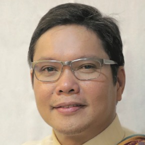
Dr. Mahar Lagmay
Executive Director, UP Resilience InstituteA University of the Philippines institute that studies disasters and climate risk and helps communities prepare. It runs Project NOAH., and Professor at the UP National Institute of Geological Sciences
Dr. Lagmay leads Project NOAHNationwide Operational Assessment of Hazards. Launched in 2012 under the Department of Science and Technology, with Dr. Lagmay as its head, it maps floods, landslides and storm surges for the whole country. The University of the Philippines has run it since 2017., which mapped flood, landslide and storm-surgeA storm surge is seawater pushed ashore by a typhoon's winds. Yolanda's surge in 2013 rose several metres in Tacloban. hazards across the whole Philippines and made them free for anyone to use. The flood maps on this page are his team's. A Cambridge-trained geologist, he was the first Asian scientist to receive the European Geosciences Union's Plinius MedalThe European Geosciences Union's medal for interdisciplinary research on natural hazards., in 2015. In the national debate over flood control, he has argued that new concrete should be the last resort, not the first.
aalagmay@up.edu.ph · UP faculty profile
Selected work
- Project NOAH, the national hazard maps
- Devastating storm surges of Typhoon Haiyan, 2015
- Disseminating near-real-time hazards information and flood maps in the Philippines through Web-GIS, 2017
-

Dr. Diana Martinez
Assistant Professor of Architecture, College of Environmental Design, UC Berkeley
Dr. Martinez is an architectural historian of American empire. Her book Concrete Colonialism shows how the United States used concrete, infrastructure and city planning to build its rule over the Philippines. Her next book traces the colonial roots of urban renewalPrograms, mostly in mid-20th-century American cities, that cleared older and often poorer neighbourhoods to rebuild them., from Daniel BurnhamThe Chicago architect and planner who drew up plans for Manila and Baguio in 1905, when the Philippines was an American colony.'s 1905 plan for Manila to American cities. She returned to Berkeley, where she studied architecture as an undergraduate, after directing the architectural studies program at Tufts.
dianajmartinez@berkeley.edu · Berkeley faculty profile
Selected work
The same day, from 11 AM to 12 PM in B100 Blum Hall, Dr. Lagmay also gives a guest lecture in Development Engineering 203, Digital Transformation of Development, a graduate course in Berkeley's Development EngineeringA Berkeley field that designs, tests and studies technology with and for communities in low-resource settings, from water systems to digital tools. program. It has room for 20 guests on top of the class, in the order people RSVP.
A space for our community
When the Waters Rise is more than a talk. After the panel, the reception in B100 Blum Hall is a space for the Filipino community and our friends to share stories, connect and learn about each other.
- Share. Bring your family's stories of bahaTagalog for flood.. You can also share one here before the day.
- Connect. Meet students, alumni, families and the speakers. Working on a Philippine project? Add a card so people can find you.
- Learn. Visit tables from campus Filipino organizations and hear what they are working on.
Part of a Filipino student org or community group? Table at the reception. Tell us what you would like to bring and we will save you a spot.
Connect around Philippine projects
Working on something in or for the Philippines, or hoping to? Add a short card so people at the event, watching online or in the Philippines can find you, and get introductions before November 9.
Bayanihan for typhoon relief
Alongside the event, we are raising funds for the Bayanihan Response for Disaster Relief, run by NAFCON, the National Alliance for Filipino Concerns. It supports families in the Philippines hit by Typhoon Tino and Super Typhoon Uwan. Any amount helps, and every donation goes through NAFCON's own donation page.

Scan the code with your phone camera, or use the button. More about the campaign.
Where to go
The talk is in Banatao Auditorium. Afterwards we walk over together to Blum Hall, right next door, to meet the speakers. Directions by BART, car and Caltrain.
- Banatao AuditoriumRoom 310, main level of Sutardja Dai Hall, 2594 Hearst Avenue at LeRoy Avenue. The talk, 4 to 5 PM. Doors open at 3:45 PM; check in at the front desk outside the auditorium.
- B100 Blum HallJust west of Sutardja Dai Hall, joined to it by plazas and bridges. B100 is on the plaza level. Meet the speakers after the talk.

Photo by UC Berkeley Disability Access and Compliance.
Our supporters
The departments, organizations and people helping make When the Waters Rise happen.
Co-hosted with
PhilDev is supporting the reception after the talk.
Made possible by







Dr. Lagmay joins us from


Want to be featured here? Help make When the Waters Rise happen. Sponsors are thanked on this page, on the event slides, from the stage and in the recording.
About the map, your answers and the data
- Your name and email are only for the RSVP list. They never appear here or at the event.
- The map shows counts by Bay Area county and Philippine province. If you pick "Prefer not to say", you are counted but not placed.
- If you share a flood story and say yes to sharing it, a teammate reads it first. A few may be read aloud at the event, never with a name.
- The blue is where a 100-year rain would flood, shaded by depth. Guimaras, Siquijor, Sulu and Tawi-Tawi have no NOAH 100-year map in this set, and some provinces are only partly mapped. At the event, the map zooms into a few towns to show every building and street.
Data and sources
- Flood hazard: UP NOAH flood hazard maps (UP Resilience Institute), for a 100-year rain.
- Buildings: Google-Microsoft-OSM Open Buildings, combined by VIDA, which joins Google Open Buildings (CC BY 4.0), Microsoft Global ML Building Footprints (ODbL) and OpenStreetMapA free map of the world made by volunteers, like Wikipedia for maps. The streets in the town closeups come from it too.. For Macabebe, the same three sources as merged by Overture Maps.
- Streets: © OpenStreetMap contributors (ODbL), from the Geofabrik Philippines extract (for Macabebe, via Overture Maps).
- Land and province outlines: PSA administrative boundaries via HDX, and philippines-json-maps (PSA, 2023). Bay Area counties: click_that_hood.
- The floods named at the event: Flood history, from BahaWatch. Photos from Wikimedia Commons, credited where they appear.